
A-GPS Tracker
Contains adsIn-app purchases
4.4star
16.8K reviews
1M+
Downloads

Everyone
info

About this app
This is an outdoor Tracker using the A-GPS capabilities of your phone. If activated it may record your track even when the phone goes to stand-by.
It is designed in particular for hikers that want to record a new path or want to follow an existing track and, more importantly, want to avoid losing themselves during their return way.
Features:
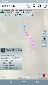
- Elevation is given relative to mean sea level ( note that most android programs don't do this)
- Your Latitude and Longitude coordinates are given in degrees and in UTM-WSG84 (published in paper maps)
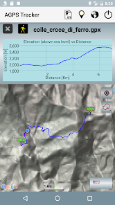
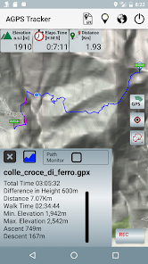
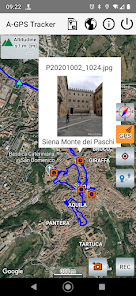
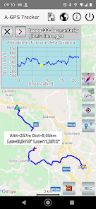
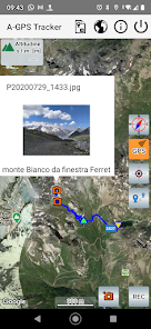
- A track is stored in a GPX file. It can be recorded, stored or loaded to/from memory and shared with other people. Its Elevation vs Distance profile can be shown on the screen.
- Statistics of a loaded GPX track will include the net walk time, ascent and descent altitude.
- A "follow path" monitor function can be enabled to provide an alarm in case you are leaving a loaded GPX path.
It is important to understand that this App is good to trace your path but if you want to measure a walked distance the accuracy is not so good. A distance is measured as the sum of distances among the points acquired every 3sec or 5meters, but GPS accuracy is about 10/20meters, if the path is casual( not like a car that follows a road) the final result can’t be very accurate. Errors up to 15% in the measurement of distances are normal.
Errors are determined by several factors. The most important are:
- quality of received satellite signals, that is poor is the sky is clouded,
- configuration/relative position of satellites that is continuously changing,
- reflections of the signals on large surfaces like walls,buildings, etc.
These are the reasons why GPS may get poor position coordinates when GPS signals are weakened by meteorological conditions and in particular in urban areas, when satellite signals are received from a multi-path propagation due to reflections on buildings.
NOTE:
GPS is used here as a generic term and refers to the capability to receive position data from signals received from satellites. Modern phones can obtain position data from more than one satellite system, i.e. not only the american GPS but also GLONASS, BeiDou and Galileo. A-GPS Tracker will receive data from all the available satellite navigation systems. In addition A-GPS (Assisted GPS) also uses ground sources like cell tower data and WiFi, that may enhance quality and precision when in poor satellite signal conditions and in particular will help to reduce time to start fixing initial position. GPS will be the source of the more accurate position: Latitude, Longitude and Altitude. Note that for hikers Altitude it is of particular importance and can be given only by GPS.
It is designed in particular for hikers that want to record a new path or want to follow an existing track and, more importantly, want to avoid losing themselves during their return way.
Features:
- Elevation is given relative to mean sea level ( note that most android programs don't do this)
- Your Latitude and Longitude coordinates are given in degrees and in UTM-WSG84 (published in paper maps)
- A track is stored in a GPX file. It can be recorded, stored or loaded to/from memory and shared with other people. Its Elevation vs Distance profile can be shown on the screen.
- Statistics of a loaded GPX track will include the net walk time, ascent and descent altitude.
- A "follow path" monitor function can be enabled to provide an alarm in case you are leaving a loaded GPX path.
It is important to understand that this App is good to trace your path but if you want to measure a walked distance the accuracy is not so good. A distance is measured as the sum of distances among the points acquired every 3sec or 5meters, but GPS accuracy is about 10/20meters, if the path is casual( not like a car that follows a road) the final result can’t be very accurate. Errors up to 15% in the measurement of distances are normal.
Errors are determined by several factors. The most important are:
- quality of received satellite signals, that is poor is the sky is clouded,
- configuration/relative position of satellites that is continuously changing,
- reflections of the signals on large surfaces like walls,buildings, etc.
These are the reasons why GPS may get poor position coordinates when GPS signals are weakened by meteorological conditions and in particular in urban areas, when satellite signals are received from a multi-path propagation due to reflections on buildings.
NOTE:
GPS is used here as a generic term and refers to the capability to receive position data from signals received from satellites. Modern phones can obtain position data from more than one satellite system, i.e. not only the american GPS but also GLONASS, BeiDou and Galileo. A-GPS Tracker will receive data from all the available satellite navigation systems. In addition A-GPS (Assisted GPS) also uses ground sources like cell tower data and WiFi, that may enhance quality and precision when in poor satellite signal conditions and in particular will help to reduce time to start fixing initial position. GPS will be the source of the more accurate position: Latitude, Longitude and Altitude. Note that for hikers Altitude it is of particular importance and can be given only by GPS.
Updated on
Safety starts with understanding how developers collect and share your data. Data privacy and security practices may vary based on your use, region, and age. The developer provided this information and may update it over time.

No data shared with third parties
Learn more about how developers declare sharing

No data collected
Learn more about how developers declare collection
Ratings and reviews
4.5
16.5K reviews

S
- Flag inappropriate
- Show review history
September 18, 2020
Tested for 1st time yesterday & worked well, recording whole time. Oddly, I was out for ~7 hours & left it running overnight to test it, & though it seems to have only counted actual movement time (good), it stopped counting total time in the middle of the night, not when last movement was recorded or when stopping it this morning. & switching measurement system doesn't change stats until reloaded, UI is dated & could be improved (e.g. rec pop-up is under stats window), & no stats per trip leg.
14 people found this review helpful

A Google user
- Flag inappropriate
June 1, 2019
Seems to work well for recording a basic track and being able to save it, etc. But it produces a persistent notification that is impossible to get rid of without rebooting the phone (even after the app itself is closed and no longer recording a track). Missing some functionality such as being able to click on a point on the track and see what the time when you recorded that point, etc.
54 people found this review helpful
A Google user
- Flag inappropriate
June 2, 2019
I really like this app and it works better than the paid apps I have used to date. There are two simple feature improvements that would make this app even better; first, an option to display next to your blue dot either distance traveled or distance remaining; second, the ability to change the off trail distance. For some reason some of the GPX files don't line up well and it would be nice to be able to add an additional offset it feet so you could still use the alarm feature.
24 people found this review helpful
What's new
This release complies with Android12 requirements. it also includes a new feature to compress in a single zip file a track and its photos, to be shared with other users.
New feature to change color and width of a track.
New feature to change color and width of a track.


